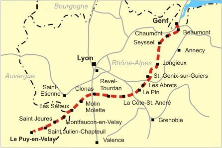
The entire route (approx. 356 km) is excellently signposted. You can't get lost and don't need a map.
My stages

| Geneva | |
| Geneva - french border | 9.0 km |
| French border - Col du Mont-Sion | 17.0 km |
| Col du Mont-Sion - Frangy | 20.5 km |
| Frangy - Serrières | 26.5 km |
| Serrières - Yenne | 26.0 km |
| Yenne - Saint Génix | 25.0 km |
| Saint Génix - Valencogne | 22.0 km |
| Valencogne - Le Grand-Lemps | 20.5 km |
| Le Grand-Lemps - La Côte-St-André | 17.0 km |
| La Côte-St-André - Revel-Tourdan | 22.2 km |
| Revel-Tourdan - Clonas-sur-Varèze | 26.5 km |
| Clonas-sur-Varèze - Saint-Julien-Molin-Molette | 25.2 km |
| Saint-Julien-Molin-Molette - Les Sétoux | 24.3 km |
| Les Sétoux - Montfaucon-en-Veley | 17.2 km |
| Montfaucon-en-Veley - Saint-Jeures | 20.0 km |
| St-Jeures - Saint-Julien-Chapteuil | 18.3 km |
| Saint-Julien-Chapteuil - Le Puy | 18.9 km |
| Le Puy-en-Velay | |
| Σ | 356.1 km |
As travel documents for the first part to Le Grand-Lemps I used the outdoor guide 'Jakobsweg GR 65' from Stein
Verlag
and the guide Chemin de Saint-Jaques de Geneve au Puy-en-Velay by Dominique Montvenoux
For the rest of the way, the recommended app from Rother for the IPhone with the route "Via Gebennensis". Thanks to GPS, you always know exactly where you are and despair if the route markings do not correspond to the Rother map.
 follow the path